

Unified Fire Prevention Project Tracking Website
Santa Barbara County Fire Department (SBCFD) serves as Santa Barbara County's Cal Fire Unit and regularly produces an Annual Strategic Unit Plan as mandated by Cal Fire that inventories the fire prevention projects SBCFD has in various stages of its planning and implementation processes.

Santa Barbara Mountain Communities Defensible Space Plan
The Los Padres National Forest (LPNF) undertook a planning effort to identify, prioritize and plan a series of fire prevention and mitigation activities to reduce the risk of wildfire to mountain communities including West Camino Cielo, Painted Cave and Rosario Park.

Community Wildfire Protection Plans (CWPPs) Where Needed Throughout the County
While several areas of Santa Barbara County benefit from the preparation of Community Wildfire Protection Plans, there are several areas of the County that do not currently have a plan that covers them.

Lompoc Fire Station Upgrades
In addition to lacking a CWPP, the City of Lompoc's main fire station is structurally unsound and in need of significant upgrades. The station houses equipment and personnel that serve the area, and the building's known structural issues create significant vulnerability…

Regional Lompoc Valley Community Wildfire Protection Plan (CWPP)
The Lompoc region has been identified as a high priority for fire prevention activities by the modeling completed by the RPP team but the region lacks a Community Wildfire Protection Plan (CWPP).

Funding for Defensible Space Assistance
While county residents generally have a high level of awareness of fire risk and high compliance with risk reduction recommendations and requirements, some community members are unable …

City of Guadalupe LeRoy Park Fuel Reduction
Guadalupe City leaders noted that an area next to Leroy Park and adjacent to the Santa Maria River is considered a high fire risk to nearby vulnerable population concentrations.

Roadside Vegetation Management
Roadside vegetation management is a high impact fire risk reduction activity and is needed in high fire risk areas throughout the county. The RPP team recommends engaging local fire …

Expanded Countrywide Chipping Program for High Risk WUI Neighborhoods
Reducing combustible vegetation in the immediate vicinity of homes, other buildings, infrastructure and transit corridors is one of the most effective actions available for fire risk reduction in the county.
Fine Scale Mapping of Critical County Resources
A key SBC Fire Department leader shared that Santa Barbara County needs to increase the pace and scale of fine scale mapping of built and natural resources to facilitate effective planning and avoid unnecessary conflicts.

Countywide GIS Public-Private Partnership
Many agencies and community based organizations maintain GIS data for internal purposes and needs. As a result, there are multiple specialized systems for particular needs and redundant technical capacity.
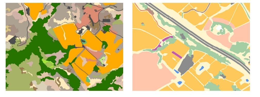
Addressing WUI Wildfire Buffer Gaps
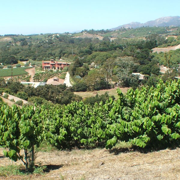
The communities throughout Santa Barbara County have varying degrees of wildfire buffer along their WUI edges. Goleta benefits from significant portions of its WUI edged by irrigated orchards

Rail Corridor Fire Prevention
Much like roadsides, vegetation along railroad corridors creates risk of fire ignition and spread. With the increasing prevalence of homeless encampments along road and railroad corridors, particularly in and near urban areas…

Dangermond Preserve Fire Resilience Projects
The Nature Conservancy stewards the 24,000-acre Jack and Laura Dangermond Preserve (JLDP) at Point Conception. JLDP is of biological and cultural significance regionally and globally.
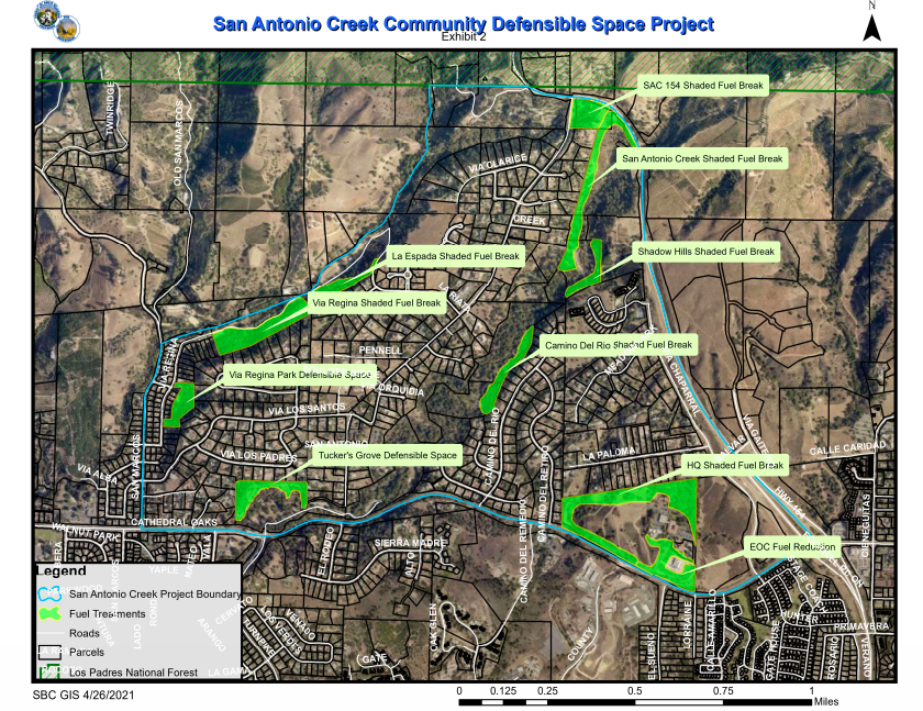
San Antonio Creek Community Defensible Space Project
In June 2021, the Santa Barbara County Fire Department received funding from the State Coastal Conservancy to implement a community defensible space project in the San Antonio Creek area foothills.

Project Fundraising, Management and Collaboration Facilitation Capacity
Building resilience will require implementing the projects listed in the RPP, and doing so requires additional capacity to catalyze partnerships, further project planning, prepare compelling grant proposals, and successfully managing projects.

Assessment of Jurisdictional Wildland Firefighting Liability: Assessment and Education for Electeds
This is an educational tool that LAFCO needs to weigh the cost of wildfire suppression when considering a SOI, or more importantly, an annexation that involves any land with inherent fire severity.

Countywide Fine Resolution LIDAR Data
There is a long term need to acquire Santa Barbara County wide, cross jurisdictional, LIDAR data in addition to the periodic orthographic overflights that are undertaken for aerial mosaic mapping product needs.
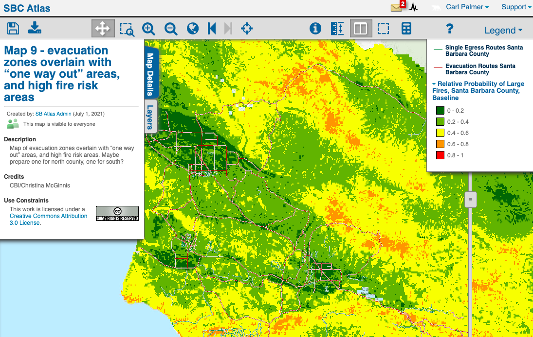
Countywide Evacuation Route Assessment
Undertake a comprehensive evacuation study countywide across all jurisdictions to review existing evacuation routes for potential improvements. This has been done for smaller areas like portions of Mission Canyon…
Firefighting Infrastructure Needs Assessment
This project would refine our understanding of countywide needs for additional wildfire infrastructure (station upgrades, engines, safe areas, crews) building on the City Gate report that documented SBCFD infrastructure needs…